New gridded maps of Koeppen’s climate classification
Jürgen Grieser, René Gommes, Stephen Cofield and
Michele Bernardi
The Agromet Group, SDRN
FAO of the UN, Viale delle Terme di Caracalla,
00100 Rome, Italy
Contact: Agromet@fao.org or juergen.grieser@rms.com
July 2006
Introduction
In 1999, the FAO Environment and Natural Resources Service published
some global climate grids, a map showing the Koeppen climate classification
next to various derived products such as the agroclimatic production potential
according to Lieth (click here for
details). Regardless of several inconsistencies which users soon
discovered, the maps turned out to be very popular and were widely copied,
pasted into other web pages as well as linked to.
We are presenting below some
updated maps based on improved recent global climate grids (click here for the
source of the original data) and a more consistent
methodology (click here [pdf] for an overview
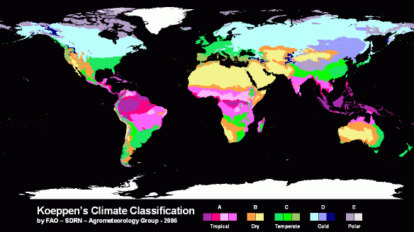
of the definition of Koeppen classes). Results of a recent recalculation of
climatic net primary production can be found here. The image below shows average
Koeppen climate for the period 1951-2000 based on the CRU and VASClimO
datasets. Click here to download
a larger version of the map. A very nice map can also be downloaded here from the Department of
Natural Sciences at the University of Veterinary Medicine, Vienna.
The new maps are presented for two time periods, to allow users to
assess changes that have taken place recently. For instance, the map below
shows in red all the areas where the climate has changed (3rd level
of Koeppen classification) between the two reference periods from 1951 to 1975
and 1976 to 2000.
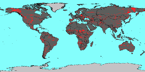
A larger version as well as a georeferenced variant of the image in
IDA/WinDisp format can be downloaded by clicking here.
Methodology
The new globally gridded Koeppen climatologies are based on
climatological observations rasterized to grids of 0.5°x0.5° degrees. They
cover 4 different periods and are based on 3 different precipitation datasets.
This leads to a total number of 12 rasterized Koeppen climatologies.
Mean annual cycles of temperature are always taken from the Climatic
Research Unit (CRU, Mitchell and Jones,
2005). Precipitation is taken from 3 different sources:
- Precipitation
data set of CRU based on about 10,000 station records (Mitchel and Jones,
2005),
- GPCC Full data,
based on all time series fragments available to GPCC (>40,000 stations,
Rudolf et al., 2005),
- GPCC VASClimO data, based
on 9,343 stations that provide at least 90% coverage within 1951-2000
(Beck, Grieser and Rudolf, 2005).
The 4 different periods are
1951 – 2000 (all),
1961 – 1990
(norm),
1951 – 1975
(early),
1976 – 2000
(late).
All different datasets are
converted to the same 0.5°x0.5° grid, which results from USGS gtopo30.
Antarctica and Greenland are left out due to lack of data.
For the users convenience
data are provided in two formats: comma separated values and IDA/Windisp
geo-referenced grids. For IDA/WinDisp format the Koeppen classes, that are
identified as strings of letters (e.g. E, or Af, or Cfa) have to be recoded as
numbers. The following coding system (“byte representation”) was adopted:
|
TROPICAL |
COLD |
||
|
Af |
13 |
Dfa |
162 |
|
Am |
23 |
Dfb |
165 |
|
As |
33 |
Dfc |
168 |
|
Aw |
43 |
Dfd |
170 |
|
|
|
Dwa |
172 |
|
DRY |
Dwb |
175 |
|
|
BSk |
63 |
Dwc |
178 |
|
BSh |
73 |
Dwd |
180 |
|
BWk |
83 |
Dsa |
182 |
|
BWh |
93 |
Dsb |
185 |
|
|
|
Dsc |
188 |
|
TEMPERATE |
Dsd |
190 |
|
|
Cfa |
112 |
|
|
|
Cfb |
115 |
|
|
|
Cfc |
118 |
POLAR |
|
|
Cwa |
122 |
ET |
213 |
|
Cwb |
125 |
EF |
223 |
|
Cwc |
128 |
|
|
|
Csa |
132 |
Other |
|
|
Csb |
135 |
Sea |
254 |
|
Csc |
138 |
Missing |
255 |
The coding is such that A
climates cover the range from 13 to 43, Cf ranges from 112 to 118 etc. Oceans
and large freshwater bodies are coded as 254, while land areas that were
assigned no climate values (for instance very small islands) are
indicated with a value of 255. The table can be downloaded here.
Downloads as comma separated
values (csv):
For each data source, the
file contains a list of comma separated values (csv) ready for the use with
Microsoft Excel. There are of 63,660 lines, each corresponding to a grid point
over land. The five columns (data items on a line) are the gridpoint number,
the longitude (in 0.01°), the latitude (in 0.01°), the fraction (in %) of the
area of the 0.5°x0.5° pixel covered by land, and the Koeppen class using the
standard 3-letter codes.
|
Comma Separated
Value Files |
||||
|
All 1951 – 2000 |
Norm 1961 – 1990 |
Early 1951 – 1975 |
Late 1976 - 2000 |
|
|
CRU |
||||
|
GPCC
Fulldata |
||||
|
GPCC
VASClimO |
||||
Downloads as IDA (Windisp):
IDA stands for Image Display
and Analysis format. These files can be easily displayed and rescaled
with Windisp. Windisp also
allows further processing of the data including the easy manipulation of colour
scales.
We provide the Koeppen maps
in their original 0.5°x0.5° resolution. Each pixel that covers a fraction of
land is drawn as a whole pixel. We furthermore resampled these maps on a 5’x5’
grid. The resulting fine-scale images still contain the classes on a .5°x.5°
grid but the coastlines are represented more precisely.
Windisp can display the
Koeppen classes up to the first, second or third letter. This allows the maps
to be displayed in full (3 letters) or medium (2 letters) accuracy or to
concentrate on the 5 major classes (1 letter). The colour scales come in two
flavors, with and without an explicit byte representation. The resulting 6
colour scales are available here.
Colour tables, all colour tables |
||
|
1-letter representation (only major climates A – E) |
||
|
2-letter representation (intermediate level of
detail) |
||
|
3-letter representation (full accuracy) |
||
A list of the byte
representations is here.
|
IDA Images |
||||
|
|
All 1951 – 2000 |
Norm 1961 – 1990 |
Early 1951 – 1975 |
Late 1976 - 2000 |
|
CRU |
||||
|
GPCC Fulldata |
||||
|
GPCC VASClimO |
||||
Additional information
For further information on
the area size covered by different Koeppen climate classes click here.
For any questions or to
report problems please contact agromet@fao.org
References
Beck, C., J. Grieser and B. Rudolf, 2005: A New
Monthly Precipitation Climatology for the Global Land Areas for the Period 1951
to 2000. Klimastatusbericht
2004, 181-190, DWD.
[pdf]
Mitchell, T., and P. Jones, 2005: An improved method
of constructing a database of monthly climate observations and associated
high-resolution grids. Int. J. Climatol., 25, 693-712. http://www.cru.uea.ac.uk/
Rudolf, B.,
C. Beck, J. Grieser, U. Schneider, 2005: Global Precipitation Analysis Products
of the GPCC. Internet publication at http://gpcc.dwd.de/ [pdf]